
What are river systems?
River systems are the corridors that connect the continents with the oceans, with the movement of water and sediment through waterways controlling the characteristics and distribution of fluvial, riparian and floodplain habitats (Stanley, et al., 2016). The supply and delivery of sediment and water to river systems is dynamic and governed by the hydrologic and geologic characteristics of a catchment, combined with modifications and alterations arising from human activities (Williams, 2012). The overarching temperature regime and rainfall pattern of a catchment exerts a strong control on the weathering of the landscape, how sediment enters river systems and when material is transported. Historical climates are also important as sediment reserves may have deposited under different conditions, such as glacial periods (Williams, 2012). Large scale, long-term changes to the landscape (development, clearing, land use change) and / or climate will induce changes to the sediment regimes of rivers.
How do rivers respond to sand mining?
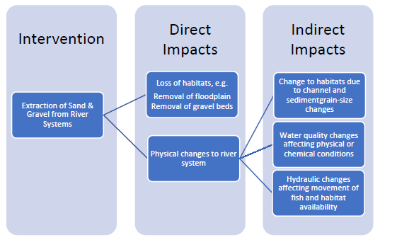
Removing sediment stores and altering sediment transport, such as can occur with sand mining, will promote physical changes in a river channel. Alluvial river systems or reaches, in which the river channel is developed within sediment deposits, are most susceptible to change, as the channel, banks, bars and floodplain are all potentially mobile. However, changes in sediment transport will also affect bedrock controlled reaches where localised sediment deposits or insets provide a substrate for vegetation and habitats exploited by riverine, riparian and terrestrial species for spawning, feeding and nesting (Owens, et al., 2005).
WWF 2018: IMPACTS OF SAND MINING ON ECOSYSTEM STRUCTURE, PROCESS & BIODIVERSITY IN RIVERS | REPORT BY LOIS KOEHNKEN
WWF 2018: IMPACTS OF SAND MINING ON ECOSYSTEM STRUCTURE, PROCESS & BIODIVERSITY IN RIVERS | REPORT BY LOIS KOEHNKEN
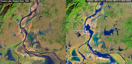
NASA Earth Observatory images which show the damage caused by sand mining in Poyang Lake and in the lower Yangtze (in picture); notice the jagged edges.
By contrasting the two images, we can see dramatic changes in the outlet channel that connects Poyang Lake to the Yangtze river. Sand removal and dredging have deepened and widened the channel significantly. These activities also have left the remaining sandbars and shores with an irregular, serrated appearance.
For instance, a 2015 study in Nature enquired why the Mekong Delta – the 3rd largest in the world – was losing 2.3 km2 of land per year. Channel mining was the primary culprit, alongside sediment retention behind hydroelectric dams and over-abstraction of groundwater. Some 27 million m3 of sand were extracted in 2012, equivalent to 20 times the annual sand flux carried by the Mekong. The authors noted that when diggers excavate stretches of the riverbed the resulting pits trap sediment, the river’s attempt to restore its equilibrium profile; hence delta is deprived of sand, which makes the shoreline more vulnerable to the toll of cyclonic storms. What’s more, tidal flux can now push saltwater 40 km upstream due to the deeper channels, salinizing croplands; river turbidity also increases, large volumes of sediment stirred up, in suspension, blocking sunlight reaching aquatic plants.
What are the impacts?
The lowering of river levels associated with sand mining may also lead to a lowering of the surrounding water table. Such a decrease can limit the effectiveness of wells and so threaten the water availability for both local people and agriculture, resulting in economic losses. The agitation and introduction of pollutants to rivers through mining may contaminate groundwater and threaten the health of those who use it.
Source:
Source:
Additional Sources:
WWF 2018: IMPACTS OF SAND MINING ON ECOSYSTEM STRUCTURE, PROCESS & BIODIVERSITY IN RIVERS | REPORT BY LOIS KOEHNKEN
https://www.nature.com/articles/srep14745
http://csis.msu.edu/sites/csis.msu.edu/files/Sand_Science%20Magazine_2017.pdf
http://geoissues.com/sand-mining-the-most-under-reported-crisis-of-all
